For critical oil and gas assets, a visual inspection only tells part of the story. To truly understand the integrity of storage tanks, pipelines, and energy infrastructure, engineers require physical measurements. Confirming physical measurements using Non-Destructive Testing (NDT) and Ultrasonic Thickness (UT) data adds crucial insights to assess the true condition of an asset.
Historically, capturing this data meant high-risk, expensive access via rope or Elevated Work Platforms (EWP). The result was often a collection of data points buried in static PDF reports, disconnected from the physical asset.
This is the gap a Structural Lifecycle Management System (SLMS) is designed to close. By integrating advanced aerial NDT data directly into a high-fidelity digital twin, engineers can move beyond visual assessment to a workflow grounded in continuous, auditable data.
The new reality: physical data meets the digital twin
This is the gap Trendspek’s Structural Lifecycle Management (SLM) platform is built to close.
The rise of specialised aerial robotics, such as Voliro, is changing how physical measurements are gathered. These advanced UAVs are engineered to perform accurate, contact-based NDT on complex structures at height, eliminating the need for hazardous human access.
These platforms use an open, modular system to integrate various NDT sensors. This allows for physical contact with structures from the air, a capability that traditional, visual-only drones lack.

Core NDT capabilities using Voliro T
Using an open, modular payload platform, tools like the Voliro T can be fitted with various NDT sensors to meet specific inspection needs:
- Ultrasonic Transducer (UT): Measures wall thickness and detects subsurface defects like cracks or corrosion. High-temperature probes can operate on assets up to 260°C, often removing the need for a costly shutdown during inspection.
- Electromagnetic Acoustic Transducer (EMAT): Ideal for rough, corroded, or dirty surfaces as it operates without a couplant (gel or oil).
- Dry Film Thickness (DFT): Specifically used to measure the thickness of protective coatings, such as epoxy or zinc, ensuring asset longevity.
- Pulsed Eddy Current (PEC): Designed for detecting corrosion under insulation (CUI) and fireproofing without requiring their removal.
By reducing the reliance on scaffolding or heavy machinery, this approach minimises operational disruptions and shortens project timeframes while providing a safer way to inspect hard-to-access locations.
The integrated workflow: from capture to action
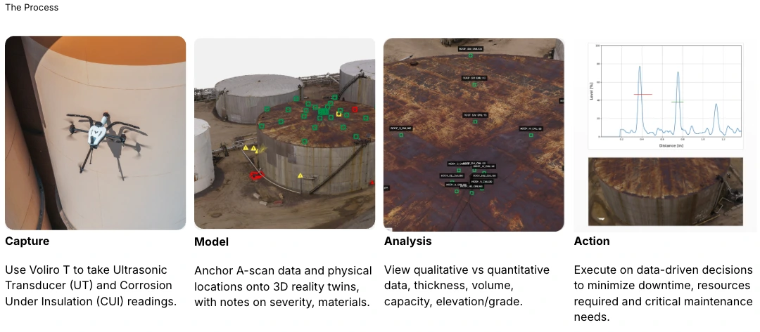
Drawing from our technical collaboration with Voliro and Osprey Integrity, the process of turning physical measurements into a system of record follows four key stages:
- Capture: Your team uses the Voliro T to take Ultrasonic Transducer (UT) and Corrosion Under Insulation (CUI) readings in areas that were previously inaccessible or high-risk.
- Model: Anchor geolocated A-scan data and physical locations onto your high-fidelity digital twin, adding specific notes on severity, materials, and condition.
- Analysis: Use the 3D environment to view qualitative versus quantitative data, including wall thickness, volume, capacity, and elevation.
- Action: Execute on evidence-based decisions to minimise downtime, reduce resource requirements, and address critical maintenance needs with confidence.
Connecting NDT Evidence to 3D Context
The real value for an engineer moves beyond the data collection to the ability to review that data in context. When geolocated NDT data is brought into a digital twin platform like Trendspek, it is anchored to a 3D spatial record of the asset.
Trendspek converts NDT, photogrammetry, and spatial data into an engineering-grade system of record. Combining these data sets enables:
- Physical data in context: Contact-based data, such as A-scan data or thickness measurements, is mapped directly onto the exact point on the 3D model. This removes the guesswork of correlating a PDF data point to a physical location on-site.
- Layered insights: You can overlay physical data with visual reality capture, thermal layers, and historical inspections. This creates a centralised source of institutional memory for every stakeholder, from maintenance planners to facility managers.
- Defensible capital decisions: By visualising physical measurements within the digital twin over time, you gain the evidence needed to track degradation. This allows your team to justify CAPEX allocation and prioritise preventative maintenance over reactive repairs.
See this workflow live in action
The Digital Progression of Asset Integrity
How can today’s infrastructure inspections keep up with tomorrow’s reliability demands? Moving toward a digital-led approach allows for a staged maturity path; beginning with improved inspection coverage and progressing toward long-term monitoring and integrated capital planning.
Our technical session with experts from Voliro and Osprey Integrity breaks down a real-world, drone-enabled inspection workflow. We explore how contact-based drones and 3D systems of record are reshaping asset integrity management.

FAQ
What is the benefit of integrating NDT data with a digital twin like Trendspek?
Integrating NDT data into a digital twin like Trendspek allows engineers to see physical measurements (like wall thickness) in their exact spatial context. This replaces static PDF reports with a dynamic system of record, making it easier to track degradation over time and make evidence-based capital decisions.
What specific data insights are available when NDT is integrated with Trendspek?
By integrating NDT data, you can move beyond simple visual inspection to analyse both qualitative and quantitative data. This includes detailed measurements of wall thickness, volume, capacity, and grade, all anchored to the exact physical location on your high-fidelity digital twin.
How does aerial NDT improve safety in oil and gas inspections?
Aerial NDT uses specialised UAVs to perform contact-based testing at height. This eliminates the need for personnel to use ropes, scaffolding, or Elevated Work Platforms (EWP), significantly reducing the risk of falls and injuries in hazardous environments.
Can NDT inspections be performed without shutting down assets?
Yes. By using advanced tools like high-temperature Ultrasonic Transducers (UT), inspections can be performed on assets operating at up to 260°C. This allows for continuous monitoring without the high cost and disruption of an operational shutdown.
What is a Structural Lifecycle Management System (SLMS)?
A Structural Lifecycle Management System (SLMS), like Trendspek, is a system of record for asset condition, risk, and capital decisions. It connects stakeholders to verified evidence across the entire lifecycle of an asset, from initial inspection through to remediation and long-term monitoring.
How do you turn aerial NDT data into an actionable maintenance plan?
The process follows a four-stage workflow: Capture physical data using the Voliro T, Model that data by anchoring it to a 3D spatial record, Analyse quantitative factors like wall thickness and elevation, and then Action evidence-based decisions to prioritise maintenance and minimise downtime.