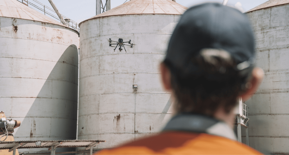
Inspecting and surveying physical assets—whether in property, energy, oil and gas, or infrastructure—is a complex and time-consuming challenge. These assets are often in hard-to-reach and precarious locations, like high-rise buildings in the CBD or remote offshore oil rigs.
That’s why commercial drones have surged in popularity for asset inspection and digital management. A rapidly evolving technology that’s quite literally taking off, drones provide efficient access to data and high-quality visuals for difficult-to-reach structures—from towers and turbines to bridges and facades.
But how do you get started with drone asset inspections? How does the process work? And more importantly, who can support you?
While the concept is simple, the execution requires careful planning to ensure the data collected is accurate, secure, and truly useful. With the right tools, guidance, and support, it becomes significantly easier — and that’s where Trendspek comes in.
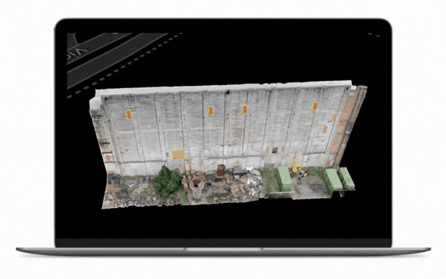
Trendspek’s world-first software platform transforms drone-captured data into a powerful decision-making tool. Rather than relying on manually taken photos stitched into a PDF report, drone capture enables the collection of hundreds of thousands of millimetre-accurate data points, built into interactive 3D models that can be accessed by stakeholders anywhere in the world.
With more than a decade of experience in drone operations, we support clients through the entire process—from selecting the right drone and planning the capture, to transforming the data into high-value insights. Whether you're running your own drone program or need us to manage the capture, we're here to help.

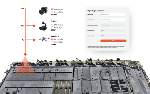
Try our Resolution Calculator
Need to determine the distance to fly your drone?
Use our free resolution calculator tool to determine the distance to capture your desired resolution.
Step 1: We become part of your drone team
When clients choose to undertake drone capture themselves, Trendspek becomes an extension of their team. We offer full support across the entire program — from reviewing asset structures to offering expert consultation. Whatever advice or questions arise, we’re ready to assist.
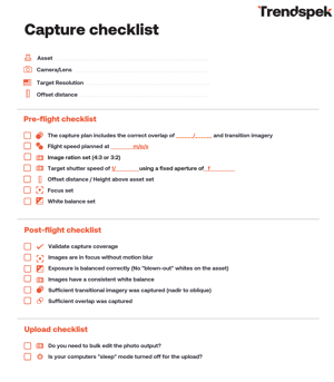
Step 2: The checklist
Once onboard, we collaborate to ensure everything is in place for the best capture outcomes.
This starts with a customised version of our drone capture checklist — an essential tool we use to plan, assess, and prepare each job.
Step 3: Pre-flight tips
Make the right camera selection
Choosing the right camera depends on a number of factors, including the asset that is being captured, the location, how close you can fly to it, and how high you will be flying overall.
We work with our clients to assess equipment they have access to, point them in the right direction of a reliable supplier, or we make the arrangements ourselves.
Get the best camera sensors
Focusing on camera sensors is important. Yes, you can capture an asset at your targeted resolution using any camera. But considering which sensors you use is what matters the most.
The larger-format sensors will produce superior image quality, with added benefits of being able to fly higher, capturing more of the asset in one frame, and needing fewer flight lines, making it significantly quicker to capture.
Refine your camera settings
Once you have your camera selection and sensors in place, it is important to look at:
- Exposure – the ideal lighting conditions typically occurring on an overcast day
- White balance – select a manual white balance to suit the lighting conditions
- Image ratio – use the camera’s biggest pixel count (usually 4:3 or 3:2)
- Focus – ensure this is set, in order to avoid images that reduce the quality of the asset
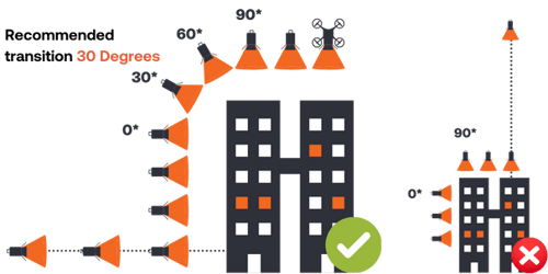
Plan for transition photos
It is important to plan for transitional imagery during the capture to avoid incomplete or fragmented corners or tower structures.
Target specific resolutions
When targeting a specific resolution, ensure accuracy when calculating the offset distance and adhere to it closely.
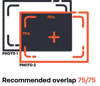
Capture overlap
Aim for the right balance of overlap to model the digital reconstruction – we recommend an overlap of 75/75.
Step 4: In-flight tips
Position data
For consistent positioning data, we recommend PPK/RTK capable drones that automatically log image positions.
Flight speed
There are several items to consider when selecting a flight speed, including minimising ‘motion blur’, the camera’s ability to achieve continuous shots and the camera settings.
Towers, facades, linear assets
Depending on the asset being captured, we will provide insights and recommendations on how to fly around each asset -- whether it is a tower, facade or linear asset, as examples.

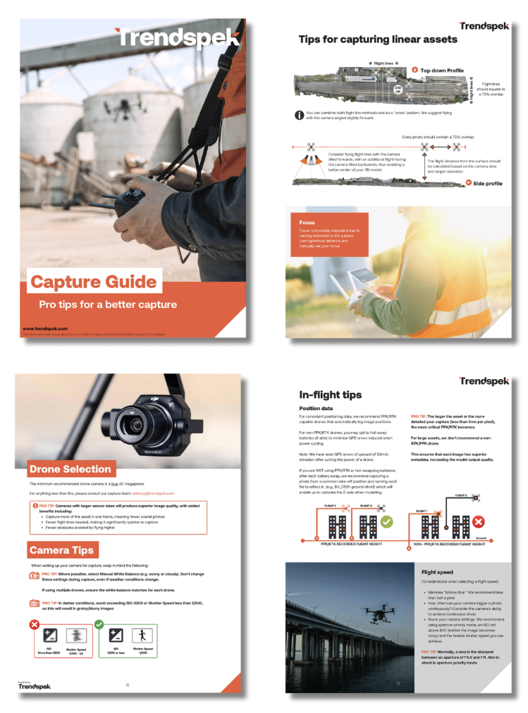
Capture Guide:
Roofing & Linear Assets
Our guide includes step-by-step instructions for capturing roofing and linear assets.
Step 5: Post-flight tips
After capture, we review the imagery against the pre- and in-flight criteria:
- Are the images in focus?
- Is exposure balanced?
- Was sufficient overlap achieved?
We also conduct a post-modelling review to identify successes and opportunities for improvement. We value honesty and openness — because that’s how our clients get the best results.
Common challenges — and how we help
Whether we’re part of your drone program or leading the capture ourselves, we help you overcome these barriers. After capturing, we process your data into 3D Reality Twins via our platform — highly accurate, interactive 3D models that allow:
- Sub-millimetre zoom
- Full 360° exploration
- A complete, contextual picture of the asset
Often, small issues — like missed focus or missing transition images — make a big difference. By guiding our clients through the process, we help them avoid these pitfalls and achieve seamless, usable 3D reality twins.
Final checklist
In addition to following the checklist mentioned above and using our Precision Asset Intelligence software and PRTs, we undertake the following steps when we’re capturing for our clients:
- Digital assessment of the site: We use available Street View, Nearmap and Google Maps
- Assessment of related air space around the asset: We make sure we can fly in the targeted space
- Identification of any obstructions that can inhibit the capture: This can include trees, arterial roads, and neighbouring properties or residential areas.
- Set up of the full plan: where the drone team will take off and land, and scan that particular asset, how long it will take in terms of flight time, how many photos are required, and how much time is needed overall
Once we have these in place, we will then go to our partner networks to implement the drone capture.
If you'd like to get in touch with us to learn more, contact us here.
More in our free
Capture Guide
For more tips, diagrams and step-by-step walkthroughs, download our free Capture Guide